You are here

Maps - NY

Primary tabs

This working group is focused on discussions about maps.

The mission of this working group is to focus on discussions about maps.

Members

Kathy Gilbeaux mdmcdonald

Email address for group

maps-ny@m.resiliencesystem.org

New York: Map Shows Where State Will Become Underwater From Sea Level Rise

Parts of Manhattan, Long Beach and Coney Island are at risk of being consumed by water as sea levels rise due to the effects of climate change in the coming century, modeling suggests.

Country / Region Tags: 
Problem, Solution, SitRep, or ?: 

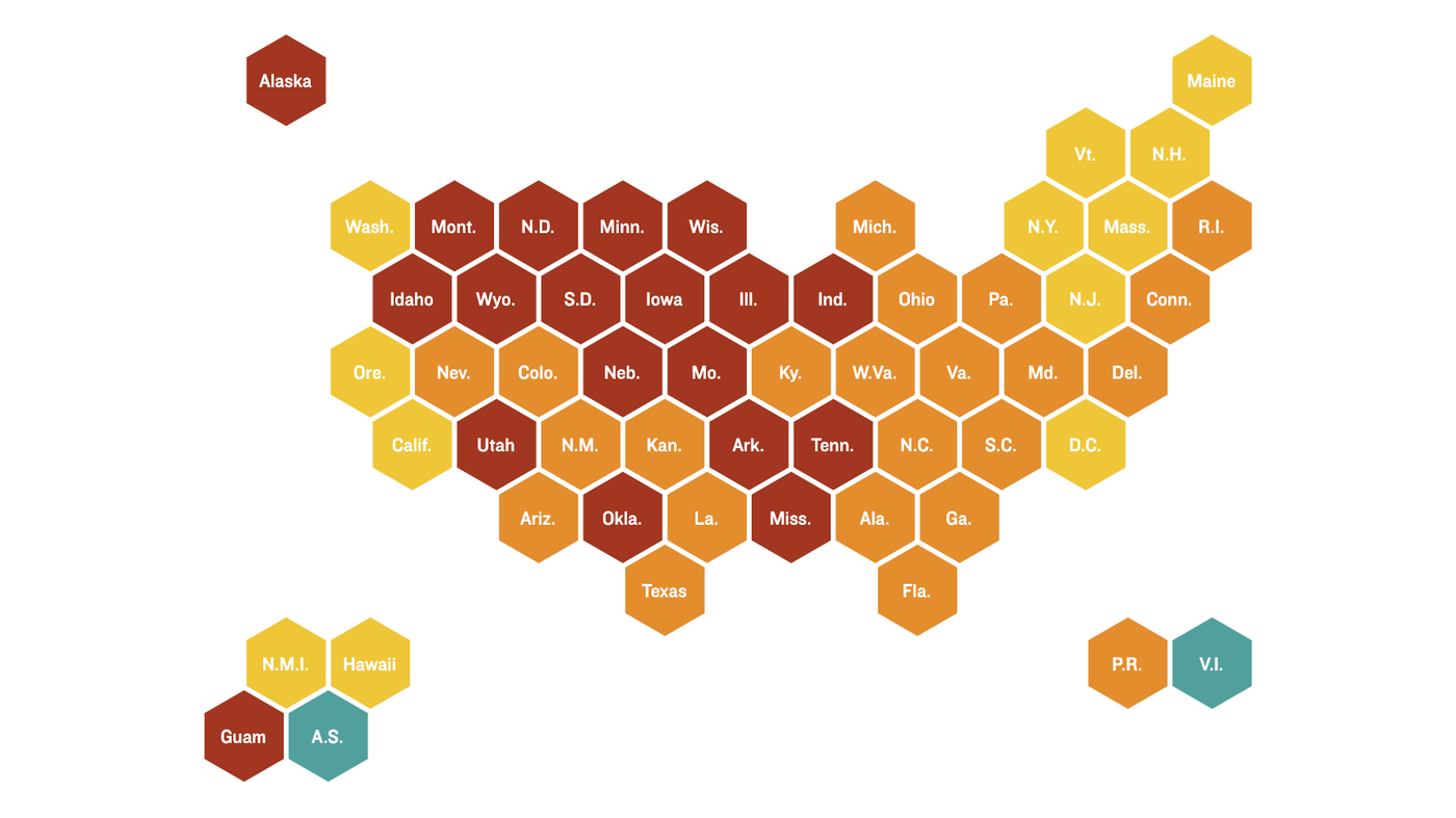
Coronavirus Maps: How Severe Is Your State's Outbreak?--NPR maps

More than 8 million people in the U.S. have had confirmed coronavirus infections and more than 225,000 have died of COVID-19. Tens of thousands of new cases are reported daily nationwide. In the graphics below, explore the trends in your state.

Country / Region Tags: 
Problem, Solution, SitRep, or ?: 

Fed Flood Maps Left NY Unprepared for Sandy — and FEMA Knew It

Flooding in Red Hook, Brooklyn after Sandy (Flickr/gunnicool)

The agency ignored state and city officials' appeals to update the maps with better data until it was too late.

wnyc.org - December 6, 2013
by Al Shaw : ProPublica / Theodoric Meyer : ProPublica / Christie Thompson : ProPublica

When Patrice and Philip Morgan bought a house near the ocean in Brooklyn, they were not particularly worried about the threat of flooding.

Federal maps showed their home was outside the area at a high risk of flood damage. . .

. . . But the maps drawn up by the Federal Emergency Management Agency were wrong. And government officials knew it.

(READ COMPLETE ARTICLE)

Country / Region Tags: 
Problem, Solution, SitRep, or ?: 

Reworking New York's Flood Map Post-Hurricane Sandy


The new map could put twice as many homes in the flood zone and raise premiums for many homeowners.

propublica.org - by Al Shaw - June 12, 2013

. . . while Sandy’s water has long receded and the bulldozers have left, a residual effect for homeowners along the city’s coastline still lurks quietly beneath the surface. It comes in the form of a July 2012 law called the Biggert-Waters Act, which will end subsidized rates for property owners who are remapped into more severe flood zones, increasing their flood insurance premiums 20 percent a year until they reach market rates, and will apply those higher rates for newly purchased property.

The potential increases, which proponents say are necessary to sustain the National Flood Insurance Program, are not widely understood by residents, and may be catching them unprepared.

(READ COMPLETE ARTICLE)

Biggert-Waters Act - Flood Insurance Reform Act of 2012

Country / Region Tags: 
General Topic Tags: 
Problem, Solution, SitRep, or ?: 

These Interactive Maps Compare 19th Century American Cities to Today

As mind-blowing as science is these days, it's probably safe to say that we're not going to invent a time machine within the next century. Through the magic of code, though, there is an entertaining alternative in the world of interactive maps. Obviously, The Smithsonian is on it.

The magazine recently dipped into David Rumsey's collection of over 150,000 maps to find some of the best representations of American cities over the past couple hundred years. With some simple programming, they were able to overlay images of vintage maps of some major cities onto satellite images from today. The results are fascinating.

See maps of New York City, Denver, Los Angeles, San Francisco, Denver, and Washington, DC

Country / Region Tags: 
General Topic Tags: 
Problem, Solution, SitRep, or ?: 
howdy folks
Page loaded in 0.728 seconds.